Americans were captivated by Storm Nadine, which had the potential to become a hurricane and hit Florida while the state was still recovering from Milton.
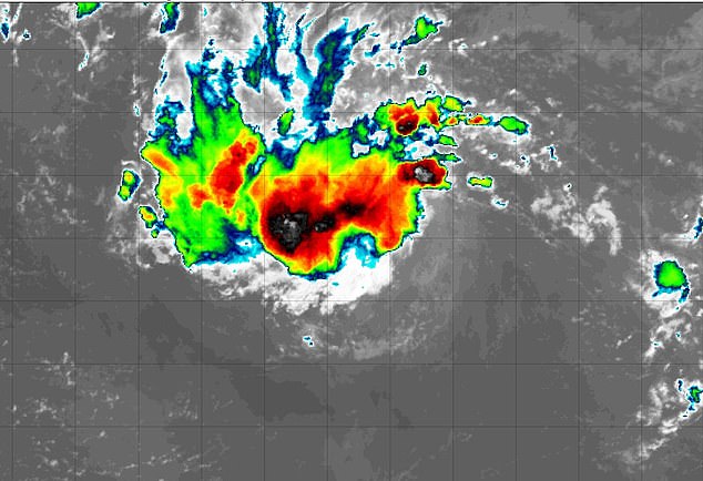
The storm, formally known as Invest A94L, has been brewing in the Atlantic for more than a week, gaining momentum as it moved west toward the United States.
The National Hurricane Center showed Tuesday that the low-pressure system had a 60 percent chance of becoming a tropical storm.
But Thursday’s update from the NHC suggested Nadine could be dead: The storm has a low 30 percent chance over the next seven days.
For the system to be named Nadine it would have to exceed wind speeds of 60 kilometers per hour, but it moves at only 32 kilometers per hour.
However, the NHC report was likely welcomed by Caribbean islands where Nadine was predicted to make landfall and trigger life-threatening effects.
While the hurricane tracking agency showed the odds are not in the storm’s favor, forecasters told DailyMail.com that “Mother Nature is unpredictable.”
Forecasters have been closely monitoring this AL94 and its potential to impact Florida and other coastal states over the past week as Americans recover from Helene and Milton.
“Showers and storms associated with a low-pressure trough located a couple hundred miles east of the Leeward Islands remain disorganized,” the NHC said in an update at 2 p.m. ET.
“Some slow development is possible over the next few days as the disturbance moves rapidly west to west-northwest at about 20 mph,” the agency added.
The storm should pass near the Virgin Islands and Puerto Rico on Friday, then near Hispaniola and the southeastern Bahamas on Saturday.
“Strong upper-level winds should end development chances by the end of the weekend,” the NHC said.
The latest potential for a future Nadine came Tuesday afternoon when AccuWeather meteorologists issued a tropical storm watch, showing the systems could cause “life-threatening” landslides in Puerto Rico and power outages in the Republic Dominican.
Rainfall was forecast to reach up to 20 inches in areas north of Hispaniola, along with 90 mile per hour winds.
Experts also said the tropical storm’s onshore winds would cause “strong surf, rip currents and coastal flooding along the Atlantic coast from the Florida Keys and southern Florida to the Georgia coast.”
AccuWeather’s senior hurricane expert Alex DaSilva said in a statement: “We have been tracking a tropical wave that moved off the coast of Africa earlier this month.

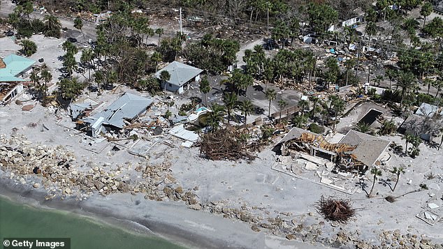
Category 3 Hurricane Milton made landfall on Florida’s west coast on October 9, pummeling the state with 100+ mph winds, tornadoes, storm surge, and up to 18 inches of rain.
“This feature has been showing some signs of organization in recent days, but could be entering a much more favorable area for tropical development this week as it approaches the Leeward Islands in the northeastern Caribbean.”
Although it is still possible that AL94 could become Tropical Storm Nadine, experts have said it is unlikely.
“An NHC forecaster takes into account multiple forecasts from computer models, along with observations of the clouds and wind structure of the tropical disturbance, to assign formation probabilities,” Brian Tang, associate professor of atmospheric sciences at the University of New York. in Albany, he said news week.
“A 20 to 30 percent chance of formation indicates a low chance of the tropical disturbance developing into a depression or tropical storm during the next week,” he said.
A storm is classified as a tropical depression when its wind circulation organizes into a cyclone and reaches wind speeds of up to 38 mph.
Tropical storms are stronger. They form when a cyclone reaches wind speeds between 39 and 73 mph.
A cyclone with winds over 74 mph is considered a hurricane. Hurricanes that reach Category 3 or higher are considered “major” and have wind speeds greater than 110 mph.
Category 3 Milton made landfall on Florida’s west coast on Oct. 9, pummeling the state with winds of more than 100 mph, a barrage of tornadoes, catastrophic storm surge and up to 18 inches of rain in some areas.
At least 17 people died from the storm, with some estimates as high as 24.
Milton arrived on the heels of Hurricane Helene, which hit the southeastern U.S. two weeks earlier and flooded states along the coast.
Helene cost between $30.5 billion and $47.5 billion in total damages across 16 states, according to CoreLogic, and has so far claimed the lives of more than 230 people, with many others still missing.
While the chances of storm system AL94 becoming the next named storm are decreasing, the 2024 Atlantic hurricane season is far from over, experts warn.
The season lasts until November 30 and conditions are still favorable for storm formation.

