Table of Contents
<!–
<!–
<!– <!–
<!–
<!–
<!–
Half of Australia can expect to face extreme heat and possible high fire danger over the long weekend, as forecasters warn of rising temperatures.
The Bureau of Meteorology has forecast a severe heatwave for southern Australia, Victoria, Tasmania and parts of southern New South Wales from Friday to Monday.

The Bureau of Meteorology has forecast a severe heatwave for southern Australia, Victoria, Tasmania and parts of southern New South Wales from Friday to Monday.
The bureau’s senior meteorologist, Angus Hines, said while south eastern parts of Australia would be bracing for warm conditions, storms were forecast for northern and western parts of the country.
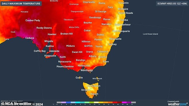
Hines said residents of South Australia and Victoria could expect to battle temperatures in the 30s and 40s throughout Saturday and Sunday.
“Melbourne is expected to be the hottest day of the summer, even though we are technically in autumn now,” he said.
Meanwhile, Tasmania is expected to reach 30 degrees or more over the weekend.
“We will see a slightly cooler day in Hobart on Sunday and even into Monday,” Hines said.
Unfortunately, residents will not experience any relief from the heat, as overnight temperature records could be broken between Saturday and Sunday.
“(It will be) above 25 degrees across much of South Australia and Victoria (overnight), while remaining above 20 degrees throughout the night in all parts of Tasmania,” Mr Hines said.

The bureau’s senior meteorologist, Angus Hines, said residents of South Australia and Victoria could expect temperatures in the 30s and 40s throughout Saturday and Sunday.
Meanwhile, a complete fire ban has been issued in Victoria, as moderate north to northwest winds move across the state.
The ban means that a fire cannot be lit outdoors or allowed to remain lit between 12:01 a.m. and 11:59 p.m. on Saturday.
Jason Heffernan, chief executive of the CFA, said communities should be aware of the fire danger in the areas they were traveling to this long weekend and stay informed.
“We are expecting northwesterly winds of 40km/h across the southwest in the morning with gusts to 50km/h in the afternoon before a southwesterly shift later in the day,” Mr Heffernan said.
“The central district will experience northerly winds of up to 45 km/h and gusts of 80 km/h in the central ranges.”
There are high fire danger ratings across the rest of Victoria and widespread wind gusts of up to 60km/h are expected to reach the western part of the state in the afternoon.
“We are asking people to follow the strict conditions associated with the TFB declaration and consider the activities they plan to do this long weekend,” he said.
“Understand how the increased fire risk will affect you and ensure your bushfire survival plan covers all possible contingencies, and stay up to date through the VicEmergency app.”
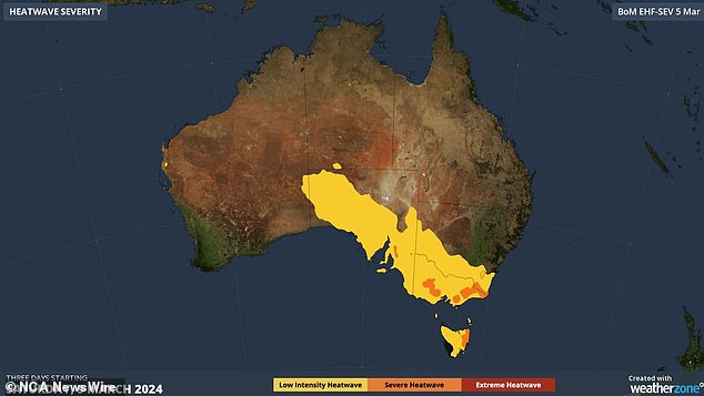

Heat wave hits several states. WeatherZone Image 3.JPG
queensland
Brisbane is expected to reach a high temperature of 29 degrees on Saturday.
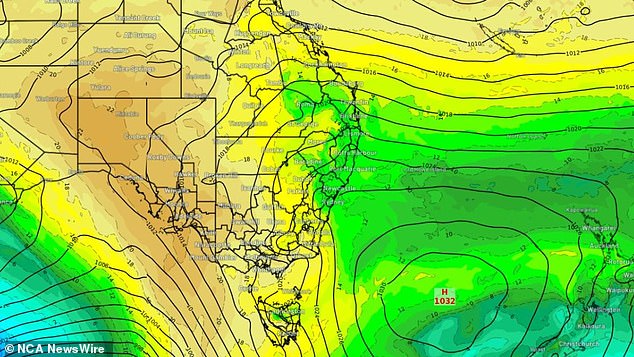
Hines said Sunday could see some rain across the Southeast.
“Much drier in the eastern part of the county, but we will see some rain along the (east) coast, mainly north of Sydney, not much rain, but some bands and patches in northern New South Wales and Queensland,” he said.
New south Wales
Coastal New South Wales is forecast to reach the upper 20s over the weekend with some light rain.
Sydney residents can expect temperatures in the mid-30s in the city, although to the west temperatures could dip into the mid-30s.
Western Australia
Meanwhile, in the west, Hines warns that heavy rain of up to 100mm to 150mm could fall in some parts of the state with fluctuating temperatures.
“It’s about average in the north, and then cooler than average in the south of Western Australia, but there aren’t too many complaints there after what has been a very hot summer,” he said.
“A slow-moving weather feature in southern WA is bringing steady rain.”
Northern parts of WA will see heavy rain on Friday, while southern parts of the state will see the brunt of the rain on Saturday.


