Table of Contents
Strong storms are expected to continue hitting Australia’s east coast into next week, while a second storm will hit Western Australia.
Areas of northeastern New South Wales and southeastern Queensland have already received more than 200mm of rain, with more storms forecast for the weekend.
Southeast Queensland was placed under a severe storm warning from Friday and the Bureau of Meteorology warned of possible flash flood and heat wave conditions.
New South Wales and Victoria will be hit hardest by storms on Sunday and Monday as a cold front moves south.
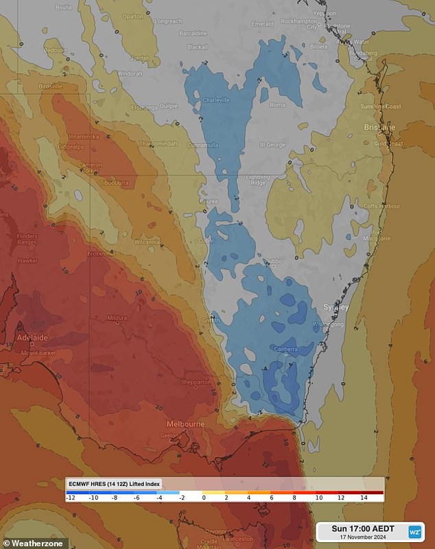
weather zone Meteorologist Ashleigh Madden explained that unstable atmospheric conditions caused by the front combining with moist air are expected to cause large storms.
“This unstable atmosphere is likely to generate some severe storms, with the main risks being heavy rain and damaging winds on Sunday and Monday,” he said.
The front and storm activity are also forecast to bring significant rainfall to the ranges of northern Victoria and southeastern New South Wales.
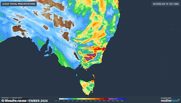
“On Sunday, daily totals could reach between 60 and 80mm of storm activity, with a risk of flash flooding,” Ms Madden said.
“While rain will ease on Monday, storm activity will continue across parts of New South Wales and Queensland early next week.”
Much of Western Australia is also at risk of thunderstorms, with inland regions of the state at greatest risk of severe conditions.
Those areas are likely to experience damaging winds.
Storms are expected to hit Victoria, New South Wales and Queensland over the weekend (pictured, the three-day accumulated rain forecast)

Southeast Queensland has been under a severe storm warning since Friday and the Bureau of Meteorology has warned of possible flash flooding and heatwaves.
brisbane
Saturday: Partly cloudy. Average chance of showers, more likely in the morning and afternoon. The probability of a storm in the west. Light winds from the east at 20 to 30 km/h in the morning. Min 21. Max 27.
Sunday: Partly cloudy. Slight chance of showers in the morning. Winds from the east to southeast at 15 to 20 km/h turning northeast at 15 to 25 km/h during the afternoon. Min 21. Max 27.
Monday: Partly cloudy. Slight chance of showers, more likely in the afternoon and evening. Chance of a storm in the afternoon and evening. Light winds that become north to northeast at 15 to 20 km/h during the day and then become light at night. Min 19. Max 29.
Sydney
Saturday: Partly cloudy. Average chance of showers, most likely in the morning and early afternoon. Northeast winds at 20 to 30 km/h. Min 18. Max 25.
Sunday: Partly cloudy. High probability of rain, more likely in the afternoon and evening. The possibility of a storm. Winds from the northeast at 25 to 40 km/h tending to the north at 15 to 20 km/h during the afternoon. Min 19. Max 28.
Monday: Cloudy. High probability of showers, more likely in the morning and afternoon. The possibility of a storm. Light winds turning from the south to southwest at 15 to 25 km/h during the morning and then turning from the southeast at 20 to 30 km/h during the day. Min 20. Max 26.
Melbourne
Saturday: Chance of fog early in the morning, mainly in the outer eastern suburbs and Dandenongs. Mostly sunny day. Winds from the north at 25 to 40 km/h. Min 11. Max 34.
Sunday: Cloudy. High probability of showers, more likely in the morning and afternoon. The possibility of a storm. Winds from the north at 25 to 40 km/h turning west at 25 to 35 km/h during the morning. Min 22. Max 26.
Monday: Cloudy. Average chance of showers, more likely in the morning and afternoon. Winds from the west at 15 to 25 km/h turning from the south to southwest at 20 to 30 km/h during the day. Min 13. Max 20.

Meteorologist Ashleigh Madden explained that unstable atmospheric conditions (forecast highlighted in blue and white) caused by the front combining with moist air are expected to cause large storms.
Canberra
Saturday: Partly cloudy. Little chance of rain. Light winds that will reach the north at 15 to 20 km/h in the early afternoon and then tend to the northeast at 15 to 25 km/h in the late afternoon. Min 11. Max 29.
Sunday: Partly cloudy. Very high probability of rain. The possibility of a storm. Light winds become from the north at 20 to 30 km/h during the morning and then tend to the northwest at 25 to 35 km/h during the day. Min 12. Max 28.
Monday: Slight chance of showers, more likely in the morning. Mostly sunny day. Winds from the northwest at 15 to 25 km/h, changing to the east at 15 to 20 km/h during the afternoon. Min 12. Max 25.
Adelaide
Saturday: Mostly sunny morning. Average chance of rain at night. Northeast winds at 25 to 35 km/h increasing to 40 km/h before changing to cooler west to southwest winds of 25 to 35 km/h in the late afternoon. Min 19. Max 37.
Sunday: Partly cloudy. Average chance of showers, most likely in the morning. The chance of a storm over the northern suburbs. Winds from the west at 25 to 40 km/h turning southwest at 20 to 30 km/h during the afternoon. Min 13. Max 22.
Monday: Partly cloudy. Winds from the southwest at 15 to 25 km/h turning from the south to southeast at 20 to 30 km/h during the afternoon. Min 13. Max 23.
Perth
Saturday: Sunny. Winds from the south to southeast at 25 to 35 km/h. Min 10. Max 24.
Sunday: Sunny. Winds from the east to southeast at 25 to 40 km/h and from the east at 20 to 30 km/h during the afternoon. Min 11. Max 29.
Monday: Partly cloudy. Slight chance of showers, more likely in the morning and afternoon. The probability of a storm in the northeast. Winds from the east at 35 to 50 km/h tending east to southeast at 25 to 35 km/h during the morning. Min 16. Max 32.
hobart
Saturday: Partly cloudy. Northeast winds at 15 to 20 km/h turning north at 25 to 40 km/h in the late afternoon. Min 11. Max 25.
Sunday: Partly cloudy. Very high probability of showers, more likely in the afternoon. Winds from the north at 20 to 30 km/h tending to the northwest at 25 to 35 km/h during the day. Min 15. Max 25.
Monday: Cloudy. Average chance of showers in the morning and afternoon. Winds from the northwest at 25 to 35 km/h turning southwest at 20 to 30 km/h during the afternoon and then trending west to southwest at 15 to 20 km/h during the night. Min 11. Max 17.

New South Wales and Victoria will bear the brunt of storms on Sunday and Monday as a troublesome cold front moves south.
Darwin
Saturday: Partly cloudy. Average chance of showers, most likely early in the morning. The possibility of a storm. Light winds that become north to northeast at 15 to 20 km/h in the middle of the day and then become light in the late afternoon. Min 26. Max 35.
Sunday: Partly cloudy. Average chance of showers. The possibility of a storm. Light winds that become from the north to northeast at 15 to 20 km/h during the afternoon and become light at night. Min 26. Max 35.
Monday: Partly cloudy. Average chance of showers. The possibility of a storm. Winds will be light from the northeast at 15 to 20 km/h during the day and then become light during the afternoon. Min 26. Max 35.

