A weather system stretching across much of Australia’s east coast continues to drench millions of Australians with the heaviest August rain in a decade as emergency crews prepare for flood rescues.
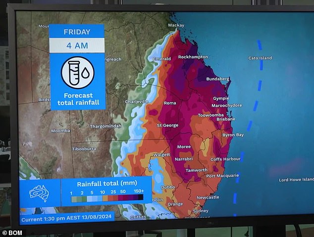
Queensland and north-east New South Wales are being hit by the worst of the weather, recording widespread rainfall of more than 100mm and prompting Bureau of Meteorology flood warnings stretching from Mackay to Byron Bay.
Severe thunderstorms with heavy rainfall that may cause flash flooding are possible on K’gari, Stradbroke and Moreton Islands. Further south, up to 100mm is expected between the Tweed Coast of New South Wales and Coffs Harbour over a 24-hour period, with isolated heavier rainfall possible.
NSW SES spokesman Andrew Edmunds said an incident management team had been set up in Lismore to co-ordinate flood rescues and crews had already responded to 163 incidents and three flood rescues across the state in the past 48 hours.
Flood alerts have been issued for parts of the Northern Rivers and mid-north coast of New South Wales, with localised river level rises and flash flooding possible along the Tweed, Brunswick, Richmond and Bellinger Rivers. Minor flood warnings have been issued for the Wilsons and Orara Rivers.
Many areas are still recovering from the record flooding that hit the region in early 2022.
In the 24 hours to Wednesday, Samuel Hill, north of Rockhampton, received 176mm, while in the first half of this week, some regions near the Queensland-New South Wales border received more than 240mm.
“Shower and flooding will remain a risk across parts of south-east Queensland and north-east New South Wales,” Bureau of Meteorology meteorologist Miriam Bradbury said.
An upper-level trough is combining with moist airflow from the coast to produce humid weather that should ease as it moves offshore beginning Thursday.
Large waves could also cause dangerous surf and erosion near beachfront properties, the bureau said.
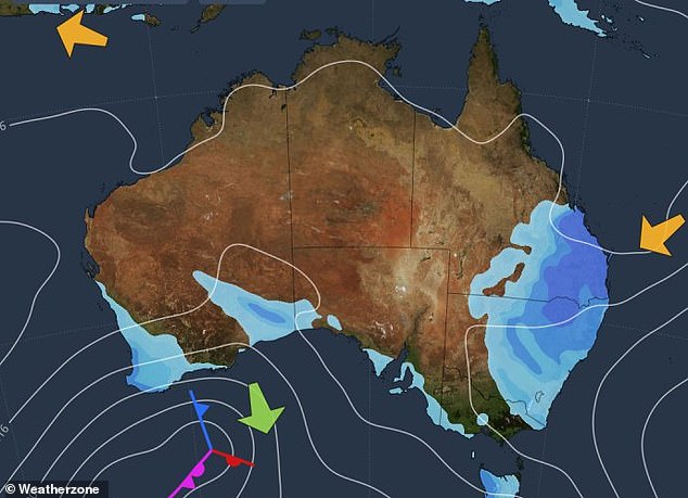
The weather system will bring heavy rain to south-east Queensland and northern New South Wales.

Sydney and Canberra are also affected by wet weather, while a separate system is producing rain over the Perth area.
“Many parts of the northern rivers, including Ballina and Lismore, have seen the heaviest August rainfall in a decade,” Sky News meteorologist Rob Sharpe said.
A separate weather system is also producing rain in the Perth area, while the rest of the country is expected to see mostly fine weather with some showers in Adelaide and Hobart.
Sydney
Wednesday: Max 18, rain. Possible precipitation: 2 to 20 mm. Chance of rain: 90 percent. Sydney Area: Cloudy. Very high chance of rain, decreasing late tonight. Light winds.
Thursday: Min 12 Max 20, a drizzle or two. Possible precipitation: 0 to 2 mm. Chance of rain: 50 percent. Sydney Area: Partly cloudy. Chance of morning fog in the west. Medium chance of showers. Light winds becoming south to southeast winds at 15 to 20 km/h early in the afternoon then becoming light late in the afternoon.
Friday: Min 12 Max 21, a drizzle or two. Possible precipitation: 0 to 2 mm. Chance of rain: 50 percent. Sydney Area: Partly cloudy. Chance of morning fog in outer west. Medium chance of showers, most likely in the afternoon and evening. Light winds.
Brisbane
Wednesday: Max 20, rain decreasing to showers. Possible precipitation: 15 to 45 mm. Chance of rain: 95 percent. Brisbane Area: Cloudy. Very high chance of rain, decreasing to showers by midday and becoming less likely from afternoon onwards. East to northeast winds at 15 to 25 km/h, becoming light in the afternoon.
Thursday: Min 16 Max 25, one or two showers. Possible precipitation: 0 to 3 mm. Chance of rain: 60 percent. Brisbane Area: Partly cloudy. Medium chance of showers, most likely early in the morning. Light winds.
Friday: Min 15 Max 26, possible rain. Possible precipitation: 0 to 1 mm. Chance of rain: 40 percent. Brisbane Area: Partly cloudy. Chance of morning fog. Medium chance of rain. Light winds.
Melbourne
Wednesday: Max 21, partly cloudy. Chance of rain: 10 percent. Melbourne Area: Partly cloudy. North winds at 15 to 25 km/h.
Thursday: Low 13 High 21, partly cloudy. Chance of rain: 10 percent. Melbourne Area: Partly cloudy. North winds at 15 to 25 km/h.
Friday: Min 12 Max 19, showers. Possible precipitation: 1 to 9 mm. Chance of rain: 90 percent. Melbourne Area: Cloudy. Very high chance of showers. Chance of a thunderstorm. North to northeast winds at 20 to 30 km/h increasing to 35 km/h before becoming north to northwest at 15 to 25 km/h during the day.

Rain will ease on Thursday, although flood warnings could remain in effect for parts of the East Coast.
Canberra
Wednesday: Max 15, 1 or 2 showers. Possible rainfall: 0 to 5 mm. Chance of rain: 70 percent. Canberra area: Cloudy. High chance of showers, reducing late this afternoon and evening. Light winds.
Thursday: Min 4 Max 20, partly cloudy. Chance of rain: 20 percent. Canberra Area: Partly cloudy. Chance of morning fog. Slight chance of rain. Light winds.
Friday: Min 2 Max 18, a drizzle or two. Possible precipitation: 0 to 4 mm. Chance of rain: 60 percent. Canberra Area: Partly cloudy. Chance of morning fog. Medium chance of showers, most likely in the afternoon and evening. Light winds becoming northwesterly winds at 15 to 20 km/h during the afternoon then becoming light overnight.
Adelaide
Wednesday: Max 21, sunny. Chance of rain: 20 percent. Adelaide Area: Sunny. Slight chance of rain later tonight. North to northwest winds at 15 to 20 km/h, becoming light in the early afternoon and then northeast at 15 to 20 km/h late tonight.
Thursday: Min 14 Max 23, late rain. Possible rainfall: 1 to 8 mm. Chance of rain: 90 percent. Adelaide Area: Partly cloudy. A slight chance of rain during the early morning, then a high chance of rain overnight. North to northeast winds at 20 to 30 km/h becoming west to northwest at 15 to 20 km/h at night.
Friday: Min 11 Max 16, showers. Possible precipitation: 5 to 15 mm. Chance of rain: 95 percent. Adelaide Area: Cloudy. Very high chance of rain, clearing before dawn and then a high chance of showers resuming during the morning and afternoon. Winds north to northwest at 20 to 30 km/h, shifting to the west at 25 to 35 km/h during the day.
Perth
Wednesday: Max 20, increasing showers. Possible rainfall: 3 to 10 mm. Chance of rain: 90 percent. Perth Area: Partly cloudy. Very high chance of showers, most likely this afternoon and evening. West winds at 25 to 40 km/h.
Thursday: Min 12 Max 19, a drizzle or two. Possible precipitation: 0 to 1 mm. Chance of rain: 50 percent. Perth Area: Partly cloudy. Medium chance of showers, most likely in the morning. Southwest winds at 20 to 30 km/h, becoming light by early afternoon.
Friday: Min 9 Max 21, increasing showers. Possible rainfall: 4 to 15 mm. Chance of rain: 90 percent. Perth Area: Cloudy. Chance of morning fog in northeast. Very high chance of showers, most likely in the afternoon and evening. Light winds becoming northerly at 20 to 30 km/h during the morning then tending to the northwest during the day.

Some forecasters have said it is the wettest August in more than a decade across large parts of eastern Australia.
Darwin
Wednesday: Max 31, sunny. Chance of rain: 5 percent. Darwin City and outer Darwin area: Sunny. Light winds becoming north to northwest winds at 15 to 20 km/h early afternoon then becoming light in the evening.
Thursday: Min 19 Max 32, sunny. Chance of rain: 5 percent. Darwin City and outer Darwin area: Sunny. Light winds becoming northwest to northeast winds at 15 to 25 km/h early afternoon then becoming light in the evening.
Friday: Min 20 Max 32, sunny. Chance of rain: 5 percent. Darwin City and outer Darwin area: Sunny. Light winds becoming northwest to northeast winds at 15 to 25 km/h during the afternoon then becoming light overnight.
Hobart
Wednesday: Max 18, a drizzle or two. Possible precipitation: 0 to 4 mm. Chance of rain: 60 percent. Hobart Area: Cloudy. Medium chance of showers, most likely late morning and afternoon. Northwest winds at 15 to 20 km/h, becoming light by early afternoon.
Thursday: Min 9 Max 15, a drizzle or two. Possible precipitation: 0 to 2 mm. Chance of rain: 60 percent. Hobart Area: Partly cloudy. Medium chance of showers, most likely overnight. Light winds becoming easterly at 15 to 20 km/h early in the afternoon, then becoming light late in the evening.
Friday: Min 10 Max 17, showers. Possible precipitation: 0 to 6 mm. Chance of rain: 80 percent. Hobart Area: Cloudy. High chance of showers. Light winds.


