Temperatures are set to soar across southeastern Australia over the next few days, with forecasters warning of a record autumn heatwave.
Melbourne is expected to bake on Monday with the Bureau of Meteorology predicting a top of 37C after a low of 24C. The rest of the state is also expected to swell with temperatures in the mid to high 30s.
Adelaide’s temperature peaked at 38C after an uncomfortably low of 27C overnight. Warm conditions in the high 30C and low 40C are forecast for most regional areas of South Australia.
The bureau warned of heatwave conditions in parts of SA, Victoria, New South Wales and Tasmania until Wednesday.
Authorities have issued a total fire ban for Monday, covering most of South Australia and Victoria’s south-west.
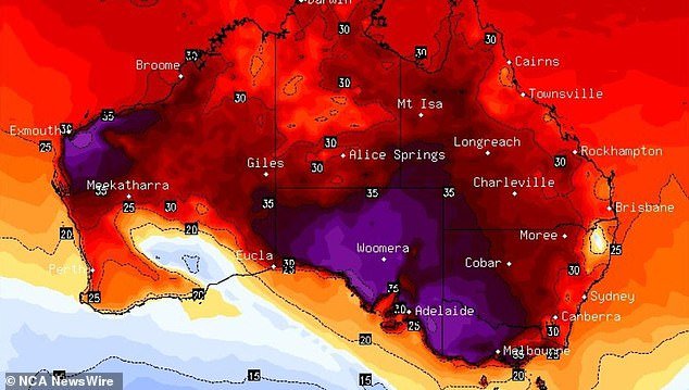
South Australia is experiencing a severe heatwave and fire danger conditions (pictured, heat forecast map)
Sydney
In Sydney, temperatures are expected to rise to 27C on Monday followed by a top of 29C on Tuesday.
Similar conditions are expected for the rest of the week with partly cloudy skies and temperatures ranging from 24C to 31C with a chance of showers on Friday.
Melbourne
Monday is expected to be the city’s hottest day this week with a top of 37C after a scorching weekend.
Tuesday’s high is much lower at 24C followed by 21C on Wednesday.
Brisbane
A maximum temperature of 20C is expected for Brisbane on Monday.
Partly cloudy conditions will continue throughout the week with potential showers and maximum daily temperatures of 29C to 30C.
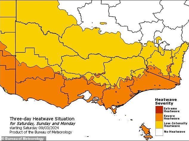

Most of Victoria is sweltering through record high temperatures (pictured, heat wave outlook map)
Canberra
Fog over Canberra on Monday morning is set to clear for a mostly sunny afternoon with temperatures topping out at 30C.
Tuesday also looks mostly sunny with a top of 33C.
However, cloudy weather is expected on Wednesday before showers on Thursday and Friday.
Adelaide
Temperatures in Adelaide are set to cool through the week from a peak of 38C on Monday to 33C on Tuesday and Wednesday followed by 24C on Thursday.
The falling temperatures are expected to be combined with increasingly gray skies ahead of possible showers on Thursday.
Hobart
Possible showers over Hobart on Monday and Tuesday are set to partially clear on Wednesday.
Monday is expected to be the city’s hottest day with a top of 27C, falling to 20C on Tuesday and 21C on Wednesday.
Perth
Perth expects a dry week with partly cloudy skies. Monday will start sunny and reach 30C with easterly winds.
Winds easing on Tuesday, remaining partly cloudy with a high of 30C.
Similar conditions will continue through Thursday, with stronger easterly winds.
A slight chance of showers will emerge on Friday, continuing into the weekend.
Darwin
Possible storms over Darwin are set to taper off from Monday with only a chance of showers through next week.
High temperatures in the city are expected to remain in the low 30s until the end of the week.
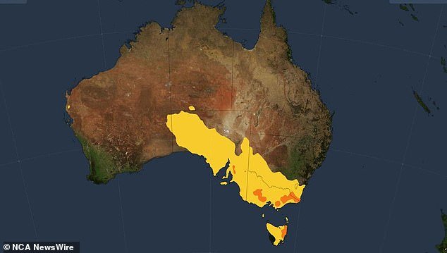

A heatwave affecting several states (pictured) saw several events canceled over the weekend, including Melbourne’s famous Moomba Parade
Records broken
The temperature peaked at 36.9C in Melbourne late on Sunday, with Avalon recording 40C and Geelong 39.6C.
It followed a record-breaking Saturday night in the Victorian capital with the mercury hovering around 30 degrees until Sunday morning, when it fell to 27.3 degrees – toppling the previous record March minimum temperature of 26.5 degrees in 2013.
Hobart was also stifling on Saturday night with a minimum temperature of 24C, well above the previous March record of 21.1C.
In SA, Adelaide recorded a top of 38.8C on Sunday as the mercury soared into the high 30C and 40C across most of the state.
Extreme conditions on Saturday forced event organizers to cancel some outdoor festivals and parades.
Melbourne’s famous Moomba Parade was canceled on Saturday due to safety concerns for performers and spectators.
Patrons at the Pitch Music and Arts Festival in south-west Victoria were asked to leave on Saturday morning as those yet to arrive were warned to stay away.
One of the stages at Adelaide’s WOMAD was closed due to the heat on Sunday, while a handful of other events were postponed until late in the evening or cancelled.
