Table of Contents
Australia experienced its second warmest year in 2024 since reliable records began in 1910, and the first week of 2025 doesn’t look any colder.
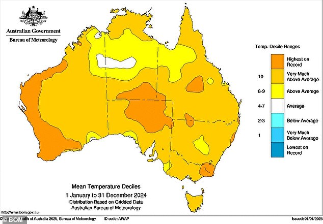
Australia’s average temperature for 2024 was 1.46°C above the 1961-1990 average, marking the 24th consecutive year the country has failed to record a below-average average temperature.
Last year was second only to 2019 as the warmest since records began, when temperatures were 1.51°C above average.
“What makes 2024 exceptional is that, unlike 2019, there was quite a bit of rain in Australia, with 2024 being the country’s wettest year since 2011 and its eighth wettest year according to records dating back to 1900,” said Ben Domensino of Weatherzone.
‘Historically, Australia’s warmest years have coincided with periods of low rainfall and drought. While some parts of southern and western Australia saw mediocre rainfall in 2024, most of the country was abnormally wet.
The highest temperature, 49.9°C, was recorded at Carnarvon Airport on February 18, equal to the eighth highest temperature ever observed in Australia.
The country’s coldest temperature was recorded in Liawenee, Tasmania, on July 4, at -13.5°C, while the continent’s coldest record was -11.1°C in Thredbo on July 3.
Tully, in northern Queensland, took the prize for the highest rainfall, recording 488mm over the 24 hours ending at 9am on February 24.
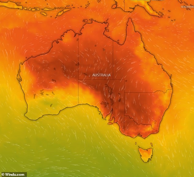
Australia will begin 2025 with a heatwave after recording its second hottest year in 2024 (pictured, temperature forecast for midday Sunday)

Australia’s average temperature for 2024 was 1.46°C higher than the period 1961-1990, marking the 24th consecutive year in which the country failed to record a below-average average temperature.
While many Australians were confident of a cooler 2025, a heatwave will bring last year’s high temperatures into the new year.
The heatwave will affect much of the country, with temperatures expected to be 12°C higher than average in some areas.
According to the Bureau of Meteorology, severe to low intensity heatwave conditions are forecast for parts of the Cape York Peninsula in Queensland, parts of the north-west of the Northern Territory, parts of the southern hinterland in Western Australia and parts of western Australia. South Australia.
Low intensity heatwave conditions in parts of the ACT and central, northwestern and southern New South Wales, parts of northern and southwestern Queensland, parts of the Top End, much of eastern WA, as well as parts of the Kimberley , Pilbara and North West WA. parts of Yorke Peninsula, Eyre Peninsula and Kangaroo Island and eastern and southern South Africa, parts of eastern and central Victoria, and isolated areas in Tasmania.
Perth has already experienced scorching conditions with 38C recorded on New Year’s Day.
It was the city’s hottest start to the year since 1997, when temperatures reached 42°C.
Heatwave conditions are expected to worsen in eastern Australia as hot, dry air moves across South Africa and Victoria over the weekend before reaching New South Wales on Sunday and Monday.

The highest temperature, 49.9 ° C, was recorded at Carnarvon Airport on February 18 (pictured, average temperatures in Australia for 2024)
Sydney
Friday: Cloudy. Slight chance of showers in the morning and early afternoon. Light winds that become east to northeast at 15 to 20 km/h in the middle of the day and then become light in the late afternoon. Min 20. Max 26.
Saturday: Sunny morning. Chance of a thunderstorm in the western exterior during the afternoon and evening. Winds will be light from the northeast at 15 to 25 km/h during the day and then become light overnight. Min 20. Max 29.
Sunday: Mostly sunny. Little chance of rain in the west, almost none elsewhere. Chance of a storm in the west during the afternoon and evening. Winds from the north to northeast at 15 to 20 km/h, trending east to northeast at 15 to 25 km/h during the day and becoming light at night. Min 21. Max 32.
Melbourne
Friday: Sunny. Winds from the southeast to southwest at 15 to 25 km/h and will become light in the late afternoon. Min 12. Max 29.
Saturday: Mostly sunny. Winds from the north to northwest at 15 to 25 km/h, trending west to northwest during the afternoon and then trending southeast to southwest at 15 to 20 km/h during the night. Min 17. Max 38.
Sunday: Cloudy. Slight chance of showers, more likely in the afternoon and evening. Chance of a thunderstorm over nearby hills during the afternoon and evening. Light winds from the north to northeast at 15 to 25 km/h during the morning. Min 21. Max 34.

A heatwave is expected to affect much of the country, with some areas reaching temperatures 12C higher than average.
brisbane
Friday: Partly cloudy. Average chance of showers, more likely in the morning and afternoon. Light winds that become southeasterly at 20 to 30 km/h in the morning and become light in the late afternoon. Min 21. Max 29.
Saturday: Partly cloudy. Average chance of showers, more likely in the morning and afternoon. Light winds that become east to southeast at 15 to 25 km/h during the morning and become light at night. Min 21. Max 29.
Sunday: Partly cloudy. Little chance of rain. Light easterly winds at 15 to 20 km/h during the day and then light at night. Min 21. Max 29.
Perth
Friday: Cloudy morning, clearing to a sunny afternoon. Winds from the south to southwest at 20 to 30 km/h. Min 17. Max 28.
Saturday: Mostly sunny. Winds from the south to southeast at 15 to 25 km/h, trending south to southwest at 20 to 30 km/h during the afternoon and then trending south to southeast at 15 to 20 km/h during the night. Min 17. Max 28.
Sunday: Sunny. Winds from the east to southeast at 15 to 25 km/h, trending southeast to southwest during the afternoon and becoming light during the night. Min 16. Max 31.
Adelaide
Friday: Sunny. Winds from the northeast to southeast at 15 to 20 km/h, trending northwest to southwest in the middle of the day and becoming weak at night. Min 15. Max 35.
Saturday: Partly cloudy. Winds northwest to northeast at 15 to 25 km/h, trending west to northwest during the day and then changing east to southeast at 15 to 20 km/h during the night. Min 21. Max 36.
Sunday: Partly cloudy. Slight chance of showers, more likely at night. Winds from the east at 15 to 20 km/h, changing to the west at 15 to 25 km/h during the morning and trending southwest at 20 to 30 km/h during the afternoon. Min 23. Max 33.
hobart
Friday: Mostly sunny. Light winds that will reach the southeast at 15 to 20 km/h in the early afternoon and become light at the end of the night. Min 9. Max 23.
Saturday: Mostly sunny. Northwest winds at 15 to 20 km/h, changing from south to southeast during the day and becoming light at night. Min 13. Max 29.
Sunday: Cloudy. Average chance of showers. Light winds that become southeasterly at 15 to 20 km/h during the morning and become light at night. Min 16. Max 21.
Canberra
Friday: Partly cloudy. Little chance of rain. Winds from the southeast at 15 to 20 km/h, becoming light before dawn and then from the northeast to southeast at 15 to 20 km/h at night. Min. 10. Max. 30.
Saturday: Partly cloudy. Little chance of rain. Chance of a storm in the morning and afternoon. Light winds that become west to northwest at 15 to 20 km/h during the day and then become light at night. Min 13. Max 34.
Sunday: Partly cloudy. Average chance of showers, more likely in the morning and afternoon. Chance of a storm in the afternoon and evening. Light winds that become west to northwest at 15 to 20 km/h during the day and then become light during the afternoon. Min 16. Max 35.

Heatwave conditions are expected to worsen in eastern Australia as hot, dry air moves across South Africa and Victoria over the weekend before reaching New South Wales on Sunday and Monday.
Darwin
Friday: Partly cloudy. High probability of rain, more likely in the late morning and afternoon. The possibility of a storm. Light winds. Min 26. Max 35.
Saturday: Partly cloudy. High probability of showers, more likely in the morning and afternoon. The possibility of a storm. Light winds. Min 25. Max 33.
Sunday: Partly cloudy. High probability of rain, more likely in the afternoon. The possibility of a storm. Light winds. Min 25. Max 33.


