A widespread heatwave is forecast to bring sweltering conditions across Australia, while another tropical low threatens to fuel intense storms in the country’s north.
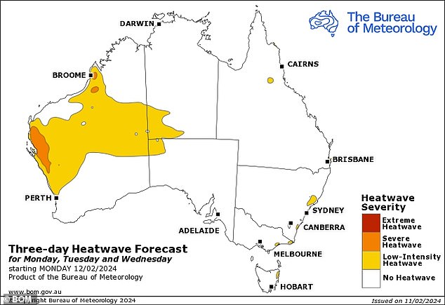
Most of Western Australia, as well as parts of Queensland, Victoria, New South Wales and Tasmania, will continue to experience heatwaves this week.
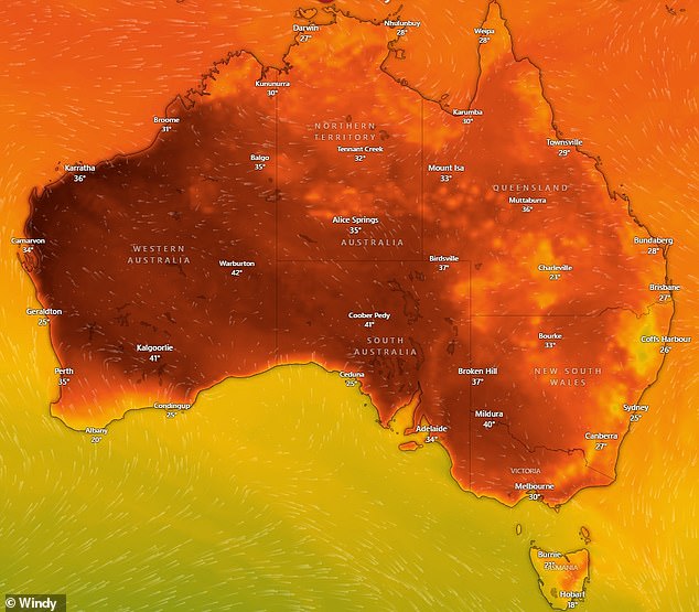
Temperatures are expected to reach 38C in some parts of the country and thousands of Australians are likely to stay home to escape the heat.
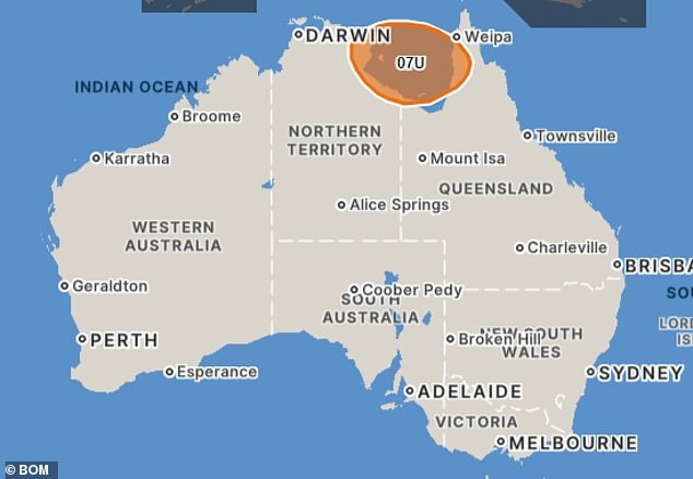
Meanwhile, a current depression will form near the Gulf of Carpentaria on Tuesday and could possibly become a cyclone later this week.
A widespread heatwave in Australia (temperature map pictured) will continue to cause sweltering temperatures this week

Adelaide is forecast to be Australia’s hottest capital on Monday with temperatures reaching 38C.
Sydney
Partly cloudy skies over Sydney on Monday will clear to sunny conditions on Tuesday along with a high of 31C.
However, gray skies will return to the city from Wednesday and rain is forecast until the end of the week with highs reaching 20C.
Sydney could be hit by a thunderstorm on Wednesday with wind speeds of up to 35km/h.
Melbourne
Clear skies over Melbourne on Monday are expected to turn into thunderstorms on Tuesday night, ahead of cloudy conditions for the rest of the week.
The city, along with most of southeastern Victoria, will continue to face sweltering conditions due to a low-intensity heatwave with a high of 35C on Monday and 36C on Tuesday.
Temperatures will drop sharply from Wednesday with a high of just 19°C, followed by a high of 22°C on Thursday and 24°C on Friday.
“Severe heatwave conditions are expected to ease with a cooler shift from Tuesday night into the early hours of Wednesday morning,” the Bureau of Meteorology said.
“Places likely to be affected include Bairnsdale and Mallacoota.”
brisbane
While Brisbane will technically not be affected by the widespread heatwave, the city will still face very high temperatures this week along with increased humidity due to dense cloud cover.
Rain over the Queensland capital on Monday and Tuesday will partially clear on Wednesday before developing again on Thursday.
The maximum temperature of 29°C is forecast to rise to 30°C on Tuesday and 32°C on Wednesday.
Parts of south-east Queensland and northern New South Wales recorded very heavy rainfall over the weekend, causing flooding.
“A high pressure system located over the Tasman Sea is expected to persist into early to mid-week, establishing a persistent regime of deep, moist eastward flow extending beyond the Queensland border.” weather zone said meteorologist Quincy Tut.
The Bureau has issued major flood warnings for Eyre Creek, the Flinders River and the Nicholson River.
Moderate flood warnings are in place for the Balonne River, Moonie River and Diamantina River.
Minor flood warnings have been issued for the Georgina River, Norman River, Barcoo River, Dawson River, lower Warrego River, Paroo River and Cooper Creek.

Storms over Darwin will continue until the end of the week and the northern city is still in the thick of the rainy season.

Most of Western Australia, parts of Queensland, Victoria, New South Wales and Tasmania will continue to experience heatwave conditions this week (pictured, map of heatwave affected regions)
Canberra
Canberra is forecast to experience a sunny start to the week with clear skies on Monday along with a high of 30C.
The sun is forecast to remain until Tuesday night, when showers could develop.
Those showers are expected to become storms on Wednesday before returning to drizzle on Thursday.
Adelaide
Adelaide is forecast to be Australia’s hottest capital on Monday, with temperatures reaching 38C.
Fortunately, conditions will be cool from Tuesday with highs of 27C and 25C on Tuesday and Wednesday.
Temperatures are expected to rise as the week progresses to a high of 35C on Sunday.
Darwin
Storms over Darwin will continue until the end of the week and the northern city is still in the thick of the rainy season.
However, conditions could worsen from Tuesday as Tropical Depression 07U forms over northern Australia, most likely over the interior of the Northern Territory.
The Bureau warned that the system is likely to move eastwards towards the Gulf of Carpentaria.
“There is a low risk of 07U becoming a tropical cyclone in the Gulf of Carpentaria from Wednesday and increasing to a moderate risk on Friday and Saturday,” it said.
‘Next weekend, 07U could move southwest. There is a risk of landfall on the southern coast of the Gulf of Carpentaria.’

Tropical 07U is expected to form on Tuesday and could become a cyclone (pictured) later this week.
Perth
Perth and much of Western Australia will be hit by a heatwave until the end of the week.
A severe heatwave warning has been issued for the Kimberley, Gascoyne, Central West and Great South districts.
The Bureau warned that maximum temperatures will reach between 30 and 40 degrees in the south and up to 40 degrees in the northwest.
Low intensity heatwave conditions are forecast across much of the west, north and interior of the state, including Perth and Broome.
Perth’s hottest day is expected to be Thursday with a high of 39C combined with cloudy conditions.
hobart
Partly cloudy conditions over Hobart on Monday are expected to turn to showers on Tuesday afternoon, ahead of cloudy conditions for the rest of the week.
Parts of northeastern Tasmania are expected to be hit by a low-intensity heatwave this week.
However, temperatures in the capital are forecast to fall from a high of 27C on Monday and 29C on Tuesday to mid to low 20C for the rest of the week.


