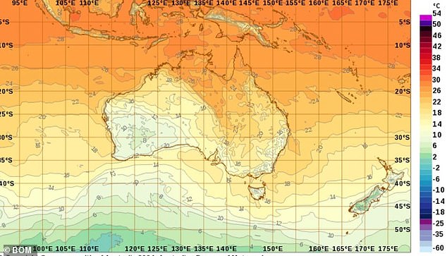
Australians are in for an unusually warm winter, with many of the country’s capital cities set to reach higher than average temperatures.
According to the Bureau of Meteorology, large areas of New South Wales, Queensland, Victoria, Tasmania, WA and South Australia are likely to experience higher than normal temperatures over the next month.
This winter is expected to surpass last year’s benchmark as the warmest winter since records began in 1910.
Average daily temperatures were 1.53°C above the long-term winter average, and each winter since 2012 was warmer than the 30-year average.
Winter sports enthusiasts are being warned this could put the ski season at risk once again after the resorts suffered one of the worst snow seasons in two decades last year.
Large areas of New South Wales, Queensland, Victoria, Tasmania, WA and South Australia are likely to exceed normal temperatures over the next month, according to the Bureau of Meteorology.
Snowy Hydro data showed that snow depth during the 2023 season was the lowest in 17 years in elevated areas of the Snowy Mountains.
Snow levels were at the lowest levels in 50 years at lower elevations.
BOM senior climatologist Simon Grainger argued the warmer forecast does not necessarily rule out good snow conditions.
“Snowfall in southeastern Australia is really determined by cold fronts and weather systems that we can forecast in the short term,” Dr Grainger told the ABC.
“Therefore, we may still have a single major weather event that could make a significant difference to the overall snow season.”
A warm winter outlook doesn’t mean there won’t be individual days of frost, colder weather or snow, but rather that the odds favor temperatures being warmer than normal overall throughout the season, he added.

Winter sports enthusiasts are being warned this could put the ski season at risk once again after resorts suffered some of the worst snowfall in two decades last year.
Experts are focusing their attention on the possibility that a La Niña weather pattern is brewing.
There are signs it could develop over the next few months, meaning it would greatly increase the chance of a wet spring and summer across most of Australia.
“Although there are some (La Niña) forecasts and some chances of a positive dipole developing in the Indian Ocean, everything currently remains neutral,” Dr Grainger said.
“That’s why we’re not seeing a very strong signal in the rain.”
BOM last month declared the end of the 2023-24 El Niño event, which would have increased eastern Australia’s chances of a dry winter into spring.
)


