Australia is currently the hottest country in the world, knocking out the top ten global towns and cities in the last 24 hours.
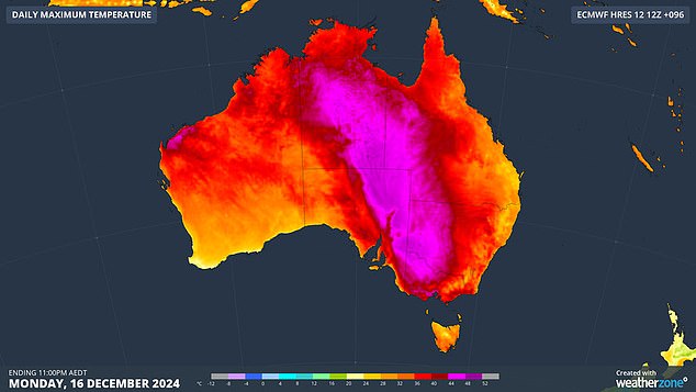
Birdsville in Queensland was the hottest place in the world at 2pm on Monday, reaching a high of 45.6C, according to data from Eldorado Weather.
Urandangi in Queensland was not far behind at 45.2°C and Walpeup in Victoria hit 45.1°C.
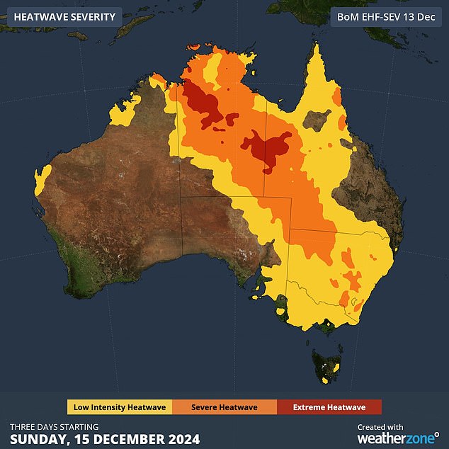
It comes as a severe heatwave hits the country, causing one of the hottest December days in years.
Parts of Victoria, New South Wales and Queensland have reached 40 degrees, while the Northern Territory faces severe to extreme heatwave conditions for much of the next three days.
High bushfire risks are expected across southeast Australia and extreme fire danger warnings have been issued.
The Mount Lofty Ranges in eastern South Australia and most of western and central Victoria, including Melbourne, are under extreme fire danger warnings.
“These hot, dry and windy conditions are likely to lead to extreme fire dangers,” Mr Narramore said.
A blast of heat has hit several states with temperatures recorded as high as 40 degrees Fahrenheit.

Melbourne is expected to hit a scorching 41C today, the hottest December day since 2019.
“That means that if fires break out in this weather, they will likely be uncontrollable and uncontainable.”
Melbourne, with an expected temperature of 41C, will face its hottest day since January 2023 and its hottest December day since 2019.
The mercury is expected to reach 46C in Mildura, in the state’s northwest, 45C in Swan Hill and 44C in Horsham.
Total fire bans have been declared across most of Victoria, with incident management teams and firefighting aircraft on alert in critical regional areas.
In Sydney, Penrith and Richmond are forecast to reach 35C on Monday and up to 41C on Tuesday. Temperatures in Harbor City are expected to remain high throughout the week.
Some parts of inland New South Wales could face even more extreme heat than Victoria.
A maximum temperature of 47C is expected in Wilcannia, in central northwest New South Wales, and 46.5C in Ivanhoe, about 180km further south.
A high fire danger warning will be in effect for much of western New South Wales on Tuesday.
Queensland also faces the risk of flash flooding on Monday in the southeast, as wet weather is forecast to reach from Yeppoon on the central coast to Brisbane.
The bureau warned southeast residents to prepare for flash flooding in the coming days.

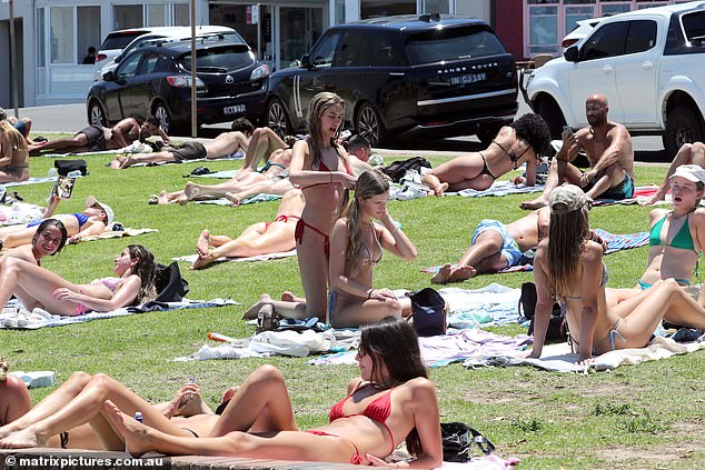
Australians are expected to stay cool by heading to the beaches as temperatures rise.

Cooling off spots will be in high demand as temperatures soar across the country.
It comes after Brisbane was hit by rain on Saturday, with the downpour causing flash flooding across the city.
Extreme temperatures will be short-lived in New South Wales and Victoria, with heatwave conditions forecast to ease on Monday night.
A cold front is moving across southern Australia on Monday morning and is expected to reach western Victoria in the afternoon, bringing relief to Melbourne and central parts of Victoria in the evening, Narramore said.
But the heat will remain for the rest of the week in Queensland and the Northern Territory.
Rain is also expected to continue throughout the week on the Queensland coast, with daily totals of up to 60mm.
Some areas may accumulate more than 150-250mm by the end of the week, Weatherzone warned.
Melbourne
Monday: Mostly sunny morning, with clouds increasing from the west in the afternoon. Slight chance of showers in the late afternoon. The chance of a storm with little or no rain starting in the early afternoon. Possibly severe storms with damaging winds. Northerly winds will reach 50 km/h and become colder from the south to southwest up to 25 km/h in the late afternoon. Maximum 41.
Tuesday: High probability of rain. The chance of a storm in the morning. Mostly sunny afternoon. Winds from the south to southwest up to 25 km/h, becoming light before dawn and then from the southwest up to 35 km/h early in the morning. Minimum 17 Maximum 24.
Wednesday: Slight chance of showers in the morning. Mostly sunny afternoon. Winds from the southwest up to 20 km/h turning south up to 30 km/h during the morning. Min 14 Max 21.
Thursday: Sunny. Winds from the south to southeast at 15 to 20 km/h, becoming light during the morning and then becoming from the south to southeast up to 25 km/h during the afternoon. Minimum 12 Maximum 27.
Sydney
Monday: Mostly cloudy morning, sunny afternoon. A slight chance of drizzle this morning. Light northeasterly winds of 20 to 30 km/h in the middle of the day. Maximum 29.
Tuesday: Sunny day. Slight chance of showers in the late afternoon and evening. Chance of a storm in the west in the late afternoon and evening. Winds from the north to northeast up to 25 km/h and will change from south to southeast up to 35 km/h in the afternoon. Minimum 20 Maximum 32.
Wednesday: Cloudy. Average chance of showers in the morning. Winds from the south at 25 to 40 km/h. Minimum 18 Maximum 23.
Thursday: Partly cloudy. Little chance of showers. Winds from the south to southeast of 15 to 25 km/h become light during the afternoon. Minimum 18 Maximum 23.
brisbane
Monday: Partly cloudy. Very high probability of rain. The possibility of a storm. Southeast winds up to 35 km/h. Maximum 28.
Tuesday: Cloudy. Very high probability of showers, more likely in the morning and afternoon. The possibility of a storm. Winds from the southeast at 15 to 20 km/h, tending to the east in the morning and becoming weak in the early afternoon. Minimum 23 Maximum 28.
Wednesday: Cloudy. High probability of rain, more likely in the afternoon and evening. The possibility of a storm. Light winds that will arrive from the east to southeast up to 20 km/h during the afternoon and then tend south to southeast during the night. Minimum 23 Maximum 29
Thursday: Cloudy. Slight chance of showers, more likely in the morning. Winds from the south at 15 to 25 km/h, tending to the southeast at 20 to 30 km/h during the morning and becoming light during the afternoon. Minimum 20 Maximum 26.
Perth
Monday: Cloud clearing. Winds from the southwest at 20 to 30 km/h, trending south at 15 to 25 km/h in the afternoon and becoming light in the late afternoon. Minimum 16 Maximum 25.
Tuesday: Sunny. Southeast winds up to 20 km/h trending east up to 40 km/h before dawn and then turning south to southeast at 15 to 20 km/h in the afternoon. Minimum 17 Maximum 35.
Wednesday: Sunny. Winds from the east to northeast at 15 to 20 km/h, changing to the southwest at 25 to 35 km/h during the morning and trending south at 15 to 25 km/h during the night. Minimum 20 Maximum 32.
Thursday: Sunny. Southerly winds up to 25 km/h, trending from south to southwest up to 35 km/h during the day and turning southeast at 20 to 30 km/h at night. Minimum 16 Maximum 30.
Adelaide
Monday: Mostly sunny morning. Slight chance of rain, most likely tonight. The chance of a thunderstorm in the late afternoon and evening. Northwest to northeast winds up to 35 km/h, trending northwest to southwest up to 40 km/h in the middle of the day and becoming southwest up to 35 km/h in the late afternoon. Maximum 38.
Tuesday: Mostly sunny. Winds from the southwest at 25 to 35 km/h, turning south in the late afternoon and decreasing to 15 to 25 km/h at night. Minimum 16 Maximum 26.
Wednesday: Sunny. Winds from the southeast at 20 to 30 km/h. Minimum 13 Maximum 29.
Thursday: Sunny. Winds from the east to southeast at 15 to 25 km/h, trending south to southwest during the day and then from the southeast at 15 to 20 km/h at night. Minimum 16 Maximum 33.
hobart
Monday: Partly cloudy. High chance of rain, most likely tonight. The possibility of a storm. Winds from the north at 20 to 30 km/h that will become light in the late afternoon. Maximum 33.
Tuesday: Partly cloudy. High chance of rain, probably early in the morning. Winds from the southwest at 15 to 20 km/h, becoming light before dawn and then from the west at 25 to 35 km/h in the morning. Minimum 16 Maximum 21.
Wednesday: Partly cloudy. Winds from the west to southwest at 15 to 25 km/h turning from the south to southeast at 20 to 30 km/h during the afternoon. Minimum 12 Maximum 20.
Thursday: Partly cloudy. Light winds from the southeast of 15 to 25 km/h during the day. Minimum 10 Maximum 21.
Darwin
Monday: Partly cloudy. Average chance of rain, most likely this afternoon and evening. Chance of a storm starting this morning. Westerly winds of up to 25 km/h become light in the afternoon. Maximum 35.
Tuesday: Partly cloudy. Average chance of rain, most likely in the late afternoon and evening. The possibility of a storm. Winds from west to southwest up to 25 km/h tending west to northwest up to 20 km/h during the afternoon and night. Minimum 27 Maximum 35.
Wednesday: Partly cloudy. High probability of rain. The possibility of a storm. Westerly winds of 15 to 25 km/h becoming light during the afternoon. Minimum 27 Maximum 35.
Thursday: Partly cloudy. High chance of rain, probably in the morning. The possibility of a storm. Light west winds at 15 to 20 km/h during the day and then light at night. Minimum 25 Maximum 33.
Canberra
Monday: Sunny. Winds will be light northwesterly at 15 to 20 km/h in the early afternoon and then become light in the evening. Maximum 37.
Tuesday: Mostly sunny morning. Slight chance of showers in the afternoon and evening. Chance of a storm in the afternoon and evening. Winds will be light from the northwest up to 30 km/h in the morning and then change to the east at 15 to 20 km/h in the late afternoon. Minimum 19 Maximum 35.
Wednesday: Slight chance of showers in the morning. Mostly sunny day. Winds from the east to southeast and light increasing up to 30 km/h during the day. Minimum 13 Maximum 28
Thursday: Sunny. Winds from the southeast up to 20 km/h, becoming light during the day and then from the east up to 25 km/h during the afternoon. Min 9 Max 28.

