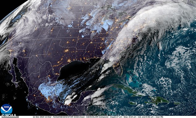
An urgent weather warning has been issued for eight states on the east coast, where a bomb cyclone is expected to bring hurricane conditions to the region.
Meteorologists predict states from Maine to New York will experience the worst impacts, including dangerous flooding and widespread power outages starting Wednesday evening.
The supercharged storm will bring wind gusts of up to 100 kilometers per hour, as well as heavy rainfall enhanced by an atmospheric river stretching 3,000 kilometers along the coast.
An atmospheric river is a long and narrow region in the atmosphere that transports heat and moisture from the tropics to the Earth’s poles.
“The impactful nature of the storm in coastal areas of the Northeast will resemble a strong tropical storm or hurricane,” AccuWeather meteorologists said.
According to AccuWeather, the metropolitan areas of Philadelphia, New York City, Boston, Providence, Rhode Island and Hartford, Connecticut could experience significant urban flooding and small streams.
“The risk of significant flooding will be further increased in the higher elevations of Vermont, New Hampshire and Maine where there is significant snowpack of several inches on the ground,” AccuWeather meteorologist Jonathan Porter warned.
That’s because rapidly melting snow can add 1 to 2 inches of water to storm runoff, and rapidly rising water can cause “life-threatening” flooding, he added.
Five states prepare for dangerous flooding and power outages as an atmospheric river and a developing bomb cyclone hit the East Coast
The National Weather Service (NWS) also issued a high wind warning Wednesday for Long Island, New York and the Connecticut coast from noon to 10 p.m. ET, with sustained winds of 25 to 35 mph and expected gusts up to 100 km per hour.
The agency has also issued this warning to parts of Maine from 7:00 PM ET Wednesday to 6:00 AM ET Thursday, as well as to all of Eastern Massachusetts and Rhode Island from 3:00 PM this afternoon to 1:00 AM ET tomorrow.
“Damaging winds will blow down trees and power lines. Large-scale power outages are expected. Travel will be difficult, especially for high-profile vehicles,” NWS officials stated.
“Stay on the lower levels of your home during the storm and avoid windows. Watch for falling debris and tree branches. Be careful if you have to drive.”
The early stages of this storm have already hit parts of the southeastern US with heavy rain on Monday and Tuesday, even prompting tornado warnings, according to AccuWeather.
The rain spread northward Tuesday night into the central Appalachians, the mid-Atlantic and southern New England.
The storm, currently developing off the East Coast, is expected to reorganize along the upper Mid-Atlantic coast on Wednesday.
Central pressure will fall, possibly dropping by 24 millibars in a span of 24 hours or less – a form of rapid intensification known as ‘bombogenesis’.
This is what creates a ‘bomb cyclone’.
At the same time, a 3,000-kilometer-long band of water vapor stretching all the way from the northeastern U.S. to the Caribbean Sea will intensify the storm’s rainfall.
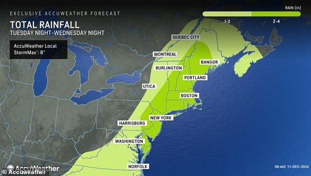
The atmospheric river and potential bomb cyclone are expected to dump a total of eight inches of rain in the Northeast
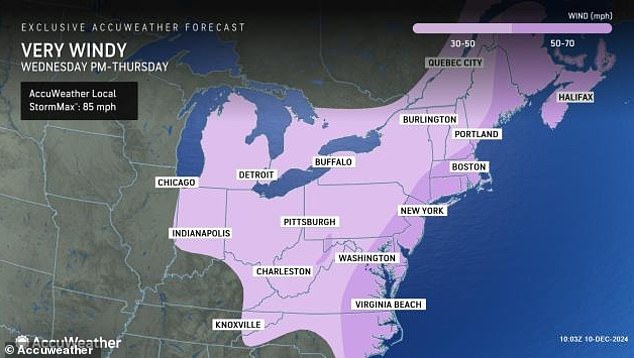
The National Weather Service (NWS) has issued high wind warnings for Long Island, New York, coastal Connecticut, parts of Maine, eastern Massachusetts and all of Rhode Island.
This moisture band is known as an atmospheric river.
Together, these weather systems are expected to dump a total of eight inches of rain across the Northeast and six inches in the Southeast.
But coastal areas in the Northeast — particularly New England — will bear the brunt of the storm’s impact as it pulls moisture from the Atlantic Ocean near the southeastern U.S. and carries it north.
Some states in this region are already preparing for very bad weather.
In Maine, some schools postponed their opening Tuesday after several inches of snow accumulated earlier in the day.
The western part of the state is bracing for freezing rain, downpours, unusually high temperatures and damaging winds, all expected to hit within a day, said Derek Schroeter, a forecaster with the National Weather Service in Gray, Maine.
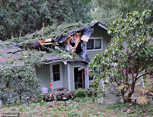
This unique storm event comes just weeks after a similar event in November rocked the West Coast and caused extensive damage in western Washington

A pickup truck was completely crushed by a falling tree in Sudden Valley, as seen in this image shared to Facebook in November
“We’re looking at the risk of slippery travel (Tuesday evening) with the freezing rain,” Schroeter said, “and we’re going to watch for the possibility of flash flooding and sharp rises in streams as temperatures rise into the 50s (10-15 Celsius).’
The state of Vermont is under a flood watch from Wednesday afternoon through Thursday morning.
The state capital, Montpelier, told residents to brace for mild flooding in the area and advised moving items in basements and other low areas up, the AP reported.
The city “will be actively monitoring river levels as this storm passes,” officials stated.
This unique storm event comes just weeks after a similar event rocked the West Coast in November.
An atmospheric river and bomb cyclone killed two people and caused widespread power outages, flooding and wind damage in the northwestern US.
If the aftermath of that storm is any indication, the East Coast could see devastating effects this week.

