Table of Contents
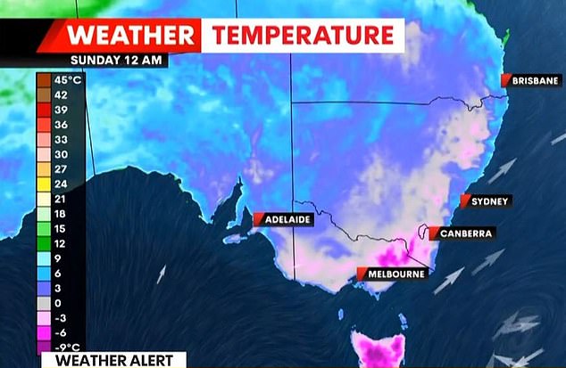
Freezing air from Antarctica will send Australians shivering through a frigid weekend, with a polar blast bringing icy winds and freezing temperatures.
The five-day cold snap will begin along the east coast of New South Wales and Victoria before finally reaching Queensland on Saturday.
The Met Office has warned that temperatures will be between two and eight degrees below average for this time of year.
Forecasters say the arrival of a strong high pressure system in the Tasman Sea will trap freezing air in the southeast well into next week.
“Frigid air will be dragged in from Antarctica by a cold front that will move across the continent this weekend,” Weatherzone said.
‘A high pressure system will quickly follow the front and remain over South Australia until at least the middle of next week, prolonging this cold snap.’
However, in good news for Sydneysiders, an 11-day spell of rain ended on Tuesday with a total of 58.6mm of rain recorded so far in July.
The longest observed rainfall streak in the city was in May 2024, when it rained for 14 days in a row and on six days it rained 20 mm or more.
Freezing Antarctic air will send Australians shivering over a chilly weekend, with a polar blast bringing icy winds and freezing temperatures (pictured, people brave the cold in Sydney)
On Tuesday and Wednesday, Sydney enjoyed clear blue skies and relatively mild temperatures of 19°C and 18°C respectively.
However, the arrival of Antarctic air will cause temperatures to plummet on Friday.
Snow is expected to fall in areas including the southern, central and northern tablelands of New South Wales, the Blue Mountains, elevated parts of the ACT, Tasmania and the Victorian Alps and even the Granite Belt in southern Queensland.
Sydney
One or two showers are expected on Friday, however the rain is not expected to be as heavy or frequent as it has been in July so far, Weatherzone said.
So far this year, Sydney has experienced four spells of rain lasting five days or more.
There were 14 rainy days from May 1 to 14, 11 days from June 30 to July 9, five days from January 14 to 18, and five days from March 15 to 19.
Five of the six months in 2024 have exceeded the monthly average, with June being the wettest month so far this year with 368.4 mm of rainfall.
This figure was almost three times the long-term average of 131.7 mm.
Dean Narramore, a senior meteorologist at the Bureau of Meteorology, said Sydney could be in for an “extended break” due to the wet weather.
“The sun is finally coming back, not just to Sydney but to the whole east coast,” he said.
‘All the rain has now passed, the low pressure that brought the bad weather has now moved into Tasmania.’
Meanwhile, the central tablelands of New South Wales are expected to see flurries of snow at higher levels around 12,000m as early as Sunday or Monday.

Millions of Australians in the southeast will shiver during a new cold snap this weekend
Melbourne
Victoria is set for a wet weekend with showers forecast for the rest of the week.
Temperatures will struggle to rise above 15°C on Friday, with lows of just 5°C.
Meanwhile, snow is expected to fall on high-elevation areas outside the Victorian Alps as a prolonged blast of icy air from Antarctica approaches.
Brisbane
The southeast part of the state will see showers and a chance of thunderstorms on Thursday before a cool and dry weekend.
Temperatures will remain below 24°C, with lows of 10°C for the next few days, before falling to just 8°C next week, with highs in the mid-20s.
The cold snap comes after a thick layer of fog formed over south-east Queensland on Tuesday night, with visibility at Brisbane Airport reduced to less than 200m on Wednesday morning.
Canberra
Temperatures are set to plummet in the nation’s capital over the next few days, with days likely to remain cloudy and cold as icy Arctic air is trapped by a low pressure system.
Elevated parts of the ACT, including relatively low hills on the outskirts of Canberra and perhaps even parts of the city itself, could see some snow over the coming days.

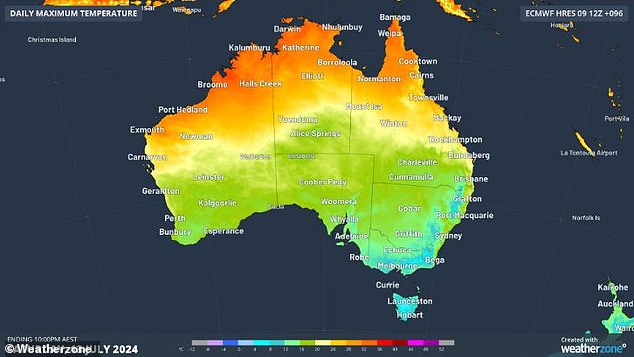
A prolonged eruption of icy air from Antarctica will cause temperatures to plummet (image shows Weatherzone map)
Perth
Cold fronts moving across Western Australia are bringing widespread rain and showers with the potential for thunderstorms.
Temperatures will struggle to rise above 20C in Perth and Saturday will see some wintry sunshine after a string of cloudy days.
Adelaide
Adelaide is set to experience very cold conditions from Saturday amid a prolonged blast of cold air from Antarctica sweeping across the southeast.
A high pressure system is expected to continue its course and remain over southern parts of the country for the next five days, prolonging the cold weather.
Rain is also expected in Adelaide over the next few days, with highs of 16°C and lows of just 8°C.
Hobart
Tasmanians will be shivering through another cold weekend as a low pressure system moves from the east coast into the country’s interior.
Like Victoria and South Australia, Tasmania will receive cold gusts of wind and rain.
Temperatures in Hobart are expected to drop by as much as 3°C on Sunday.
Darwin
Further north in the Northern Territory, conditions are fine and sunny.
Temperatures will remain between 19°C and 33°C for the rest of the week.

